They may be easily accessible tools of navigation today, but maps were once an artistic genre unto themselves, and a much-prized window into worlds that most would never see. From cosmograms, which were prevalent in almost all primary religious-systems in the Subcontinent, to cartographs in an age of exploration where scientific accuracy grew in importance — maps are particularly revealing of the political and cultural forces in play at the time. And they are an entirely enchanting way to read the past. Travel through some ideas of India and world with these maps from the Sarmaya archive.
Loka Purusha
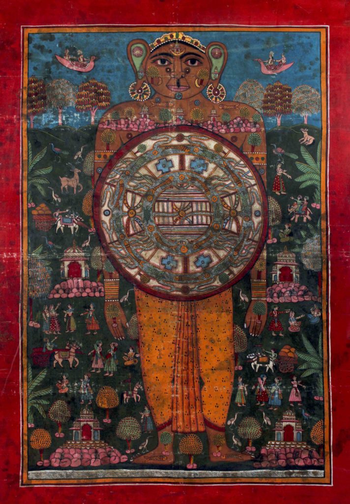
In Jain philosophy, the world is divided into three parts – the world of gods on top (Urdhva Loka), the world of men in the middle (Manushya Loka) and the world of the damned at the bottom (Adha Loka). Pictorially, this idea is often shown superimposed on a being called the ‘Loka Purusha’, which personifies the known and unknown worlds. The most important of the three worlds is the Manushya Loka, which is further split into two-and-a-half islands (adhai dvipa). This is how Jainism imagined the mortal world.
This beautiful painting of the Loka Purusha (tempera on cloth) contains the adhai dvipa in the centre — each concentric circle represents one island, topped by Mount Meru, which was believed to be the source of the world’s primary river systems. Each island circle is filled with various types of flora, and is separated from the others by thinner rings representing water bodies with creatures of the sea like fish and turtles.
The torso of the Loka Purusha depicts shrine-like structures on a rocky region representing the Urdhva Loka. The shrines also make appearances in his ears and on his forehead, here symbolising the realm of liberation or Moksha. The Adha Loka, in the lower part of the body, was traditionally used to portray violent, gruesome imagery of tormented souls in purgatory — here, however, the artist simply decided to provide the Loka Purusha with a patterned mustard dhoti instead.
Magni Mogolis Imperium (1639)
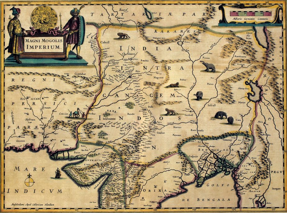
The first-ever British attempt to map the Mughal empire was by Arctic explorer and surveyor William Baffin in 1619. England’s first ambassador to Mughal India, Sir Thomas Roe, visited Jahangir’s court and managed to gather substantial geographical information that he then passed on to Baffin. The latter then accompanied Roe on his return journey from India to Persia, compiled the data collected and produced an educated impression. Known as Sir Thomas Roe’s Map, it influenced cartographers for over a century, becoming the basis for innumerable future maps of India.
Flemish-born engraver, cartographer and publisher Hendrik Hondius created this particular map of the Mughal Empire, titled Magni Mogolis Imperium, in 1639 using the Baffin map to draw his initial plans, and then expanding it based on other sources, such as travellers’ accounts. The extent of the Mughal domain is clearly shown, bordering the Persian Empire in the west across to Myanmar in the east. Important cities that fell on crucial trade routes, like Delhi, Agra, Gualiar (Gwalior) and Soret (Surat), are clearly demarcated.
The title cartouche at the top left is particularly interesting — two noblemen dressed in Mughal-esque costumes stand on either side of the Mughal insignia, which includes the sun fronted by a lion, and surrounded by names of the kings and their Timurid ancestors. The names end at Jahangir, who was the ruler at the time of Roe’s visit. But our favourites are the whimsical drawings all over the map of animals native to India, like the lion, elephant and tiger.
India Vetus (1670)
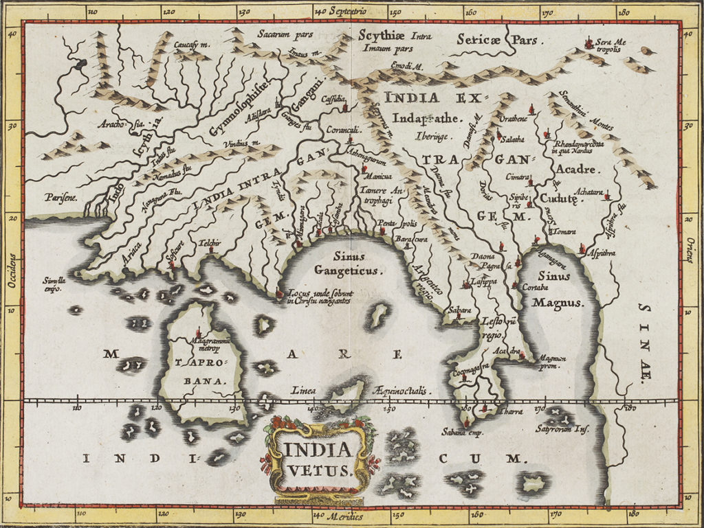
One of the earliest modern cartographers of the world, Philipp Clüver (aka Cluverius) was born in Danzig in 1580, and is widely regarded as the founder of historical geography. He is the creator of this stunning — if almost unrecognisable — map of India. Titled India Vetus, meaning ‘Old India’, this map was part of a larger series called the Introductio in Universam Geographiam (published in Amsterdam in 1641), Clüver’s most important work of six volumes. It was loosely based on Ptolemy’s map of the world, and contained descriptions and engraved maps of all countries, with a focus on human and historical considerations.
The map features a heavily truncated view of the Indian Peninsula, with the Bay of Bengal being termed the Sinus Gangeticus. The island of Sri Lanka is incorrectly placed on the left side, and is labelled as Taprobana. This is believed to be an interpretation of the word Tamraparni (or Tambapanni, meaning copper-coloured) by the ancient Greeks. Taprobana became the name that Sri Lanka was known by, and was subsequently used in many of the oldest maps of the world.
The Port of Kochi (1724)
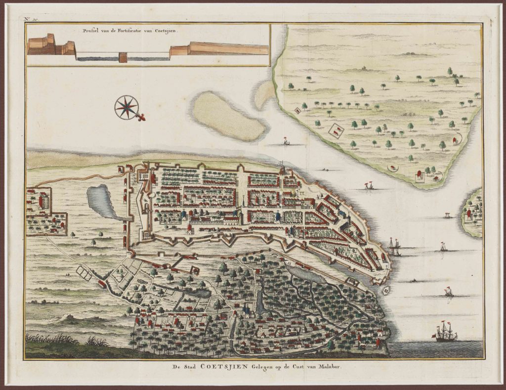
This absolutely gorgeous map, whose title translates to The City of Kochi located on the coast of Malabar, was created in the early 1700s to help sea-traders travelling from other regions to Coetsjien (Kochi). The map was a hand-coloured copper engraving by Francois Valentijn, an explorer and naturalist from the Netherlands who wrote about the history of the Dutch East Indian company and chronicled the countries of the Far East. His maps were considered very valuable, and his narrative style made him known as a prominent Dutch writer of his time.
The coastal map shows the dock as well as the landmass from a bird’s-eye vantage point. The dock entry is fortified and the embankment runs all along in the inland, embracing the fort of Kochi. The unfortified section, meanwhile, represents the local residences, filled with tiny waterways, streams, places of worship and vegetation. The top left of the map has an illustration of a profile view of the dock entry, to give travellers a clearer idea about the elevation. The elaborate attention to detail and the almost toy-like drawing style makes this map irresistible.
Carte de Bombay (1750)
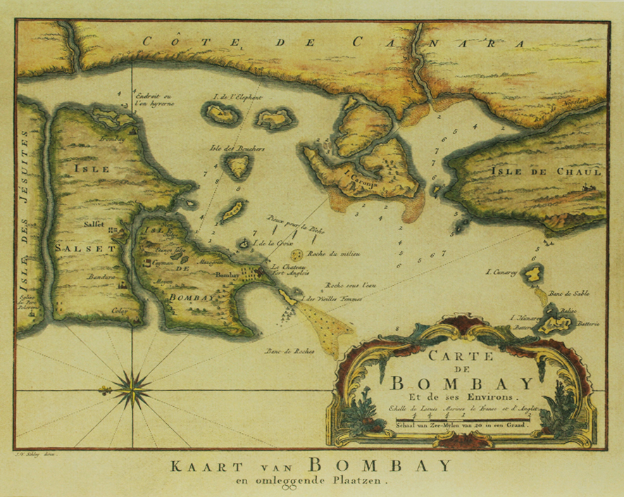
Even though Bombay (present-day Mumbai) was the centre of trade and commerce in Colonial India, strangely very few early maps survive of the region. This particular map, created in the 1700s by well-known French cartographer Jacques-Nicolas Bellin, is a rare exception. Bellin used the earlier nautical maps of the ‘Island Of Bombay and Sallset’ by Samuel Thornton which were created to aid mariners, and added new information to his version.
The map shows the Islands of Bombay and Salset, and has a unique section marked the ‘Isle des Jésuites’ on the extreme left. It is possible that this is present-day Vasai (Portuguese Bassein), as the area had a large Jewish population in the early colonial era. In the ‘Isle Salset’ and the ‘Isle De Bombay’ various important trading/residential points are marked — look out for Bandura (Bandra), Mazagoem (Mazgaon), Sion, Majem (Mahim), Fort Anglois (Fort), Isle des Vielles Femmes (Colaba or the Old Women’s Island) and Isle de l’Elephant (Elephanta Island).
On the right side of the map is a portion marked out as Isle de Chaul, which was a Portuguese town colonised around 1521 with a fort built in the region. Today, the village of Chaul lies in ruins near the town of Revanda, in the Raigarh district of Maharashtra. The presence of numbers and navigational pointers drawn over the sections showing water bodies suggests that this too was a nautical map drawn for the benefit of seafarers.
Atlas of British India (1851)
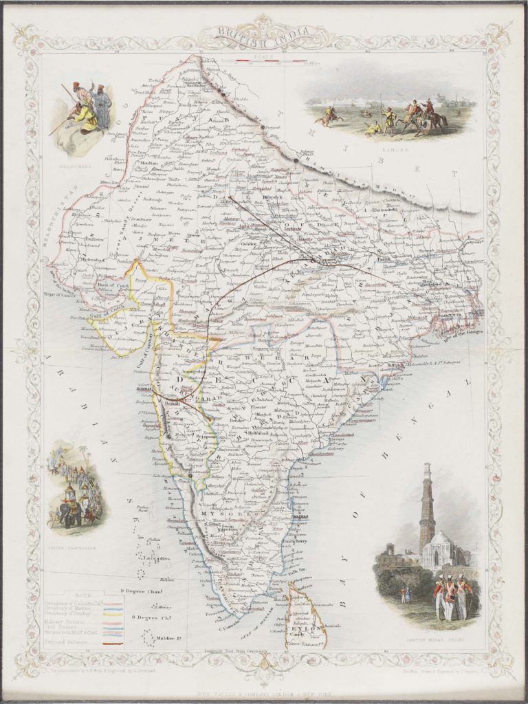
One of the most respected cartographers of the 19th century, John Tallis and Company were renowned for their accurate, intricate maps, which were prized for their decorative vignettes showing the people and landscape of the region. This is a detailed and decorative map of British India in 1851. Inside a decorative floral border, the map begins to resemble the contemporary form that we know today, and was published as part of R. Montgomery Martin’s Illustrated Atlas, one of the last decorative atlases of the 19th century.
It is a wonderfully colourful map — different colours mark out the Madras, Calcutta and Bombay Presidencies, while a red line cutting across northern India and joining Bombay in the south-west delineates the ‘proposed railway’. The proposals for an Indian Railway were first made in Madras in 1832, while the first passenger train in India ran between Bori Bunder (Mumbai) and Thane in 1853.
The vignettes on the corners include coloured depictions of Indian landscapes, architecture and people. These include a view of Lahore (top right), a view of the Cootub (Qutub) Minar in Delhi (bottom right), an Indian procession complete with elephants, camels and horses (bottom left) and ‘Beloochees’ (top left), a tribe living in the Baluchistan region in South Asia.
Concept and research by Shubhasree Purkayastha

